
introduction
Totton and Eling Neighbourhood Plan
1.1 Totton and Eling Town Council (TETC) is preparing the first Totton and Eling Neighbourhood Plan (TENP) to cover the period from 2025 – 2042. TETC is defined as a ‘qualifying body’ for this purpose in line with the Neighbourhood Planning (General) Regulations 2012 (as amended).
1.2 The Totton and Eling Neighbourhood Area was designated by New Forest District Council and New Forest National Park Authority in November 2014 as the area to which the policies of the TENP will apply. A map showing the Neighbourhood Area is shown below. The area coincides with the Town Boundary. The southern tip of the parish to the west of the A326 falls within the New Forest National Park Authority area, with the remainder under the planning area of New Forest District Council.
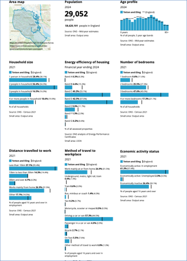
1.3 Totton and Eling has a population of just over 29,000 residents (as at Census 2021 updated 2024).
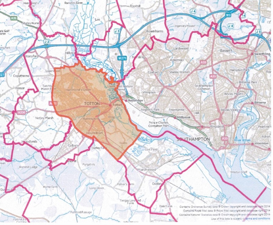
1.4 The TENP will cover the period from 2025 to 2042. This version contains draft policies for determining planning applications for the use and development of land within Totton and Eling during that period. In doing so it operates alongside other policies of the NFDC and NFNPA development plans that relate to Totton and Eling.
1.5 The TENP will be published for statutory consultation under Regulation 14 of the Regulations. Comments on the proposals and content of the Plan and its other published documents will be welcomed from everyone living and working in Totton and Eling, as well as local organisations and landowners. Consultation contact details and the closing date will be inserted before publication.
1.6 Anyone submitting comments to TETC must provide an email or postal address and contact name. TETC will keep this information confidential. However, it must forward information to NFDC and NFNPA in due course for the sole purpose of notifying all those that have submitted comments that it has received a final version of the plan for the Regulation 16 consultation and examination.
Background
History
2.1 Totton and Eling, is located on the north-eastern edge of the New Forest. It is located within New Forest District, between the New Forest National Park and the River Test, west of the city of Southampton. It has developed historically from a small rural settlement into a significant suburban town, particularly following post-war growth. The settlement sits at the head of a significant stretch of development running south along Southampton Water which includes the settlements of Marchwood, Hythe & Dibden, Fawley and Calshot. Totton itself has a cluster of hamlets and small villages to its immediate west and south including Ower, Copythorne, Netley Marsh, Ashurst Bridge and Ashurst. Many of these villages are within the New Forest National Park.
2.2 The Town historically developed around the River Test and the causeway that linked it to Southampton. Its roots lie in agriculture and river-based trade. The arrival of the railway in the 19th century encouraged industrial activity with Totton’s accessibility to Southampton making it attractive for timber, shipping, and related trades. After World War II, Totton experienced rapid suburban development, accommodating overspill from Southampton. This included housing estates and retail expansion.
2.3 By the late 20th century, Totton had evolved into a service-based economy. The town centre became more structured, though with elements of piecemeal development. Whilst much of Totton is modern, some historic assets remain, including old farm buildings, churches, and riverside features in Eling reflecting its pre-industrial past.
Profile
2.4 Totton and Eling has a population of just over 29,000 people. Its age profile overall has a slightly older population, this is far more consistent with the average across the country, than elsewhere in the New Forest, which has a significantly higher demographic. There are more persons between the ages of 50 and 60 than the national average, with a slightly lower demographic in the 20 – 30 age categories.
2.5 Pockets of relative deprivation are small and generally associated with established social housing estates, namely the Calmore estate; Water Lane near the college; an area north of Ringwood Road between Calmore Road and West Totton, Testwood (Stanley Road); and Hounsdown. A pocket of deprivation can also be found in the town centre south of the railway line and along Rumbridge Street. The highest levels of deprivation (around 14%) are in the Calmore estate and a small cul de sac of housing south of Water Lane.
2.6 Population density is low across a large part of the town, with no area exceeding 12,642 people per square kilometre compared with areas of neighbouring Southampton with substantial inner-city pockets having over 32,000 people per square kilometre. It is fair to say the town is distinctly suburban or even semi-rural. The lowest population densities in fully built-out wards can be found in the town centre.
2.7 Around 63.6% of the population is defined as economically active which is around 10% higher than the national average. It has more 2 person households than the average, but very slightly fewer 1 and 3 person households. A much higher number of its households have 2 or more vehicles than average.
2.8 It has many fewer 1, 2 bedroom and 4-bedroom dwellings with more 3 homes bedroom homes. The community has below the national average of people working from home and slightly higher than average number of people travelling less than 10km to work, reflecting the close proximity to both Southampton and employment opportunities along the Waterside.
2.9 The Solent Freeport website sets out that the initiative will unlock significant investment, create thousands of new jobs and enhance the region’s credentials as a global gateway into the UK. Tax sites within the New Forest will play a vital role in the delivery of the Freeport – with land at the former Fawley Power Station, Exxon Mobil, ABP’s Strategic Land Reserve and Marchwood Port (Solent Gateway) making up the majority of the Southampton Waterside tax site. One key benefit of the Freeport is the retention of business rates above a fixed base level on tax sites for a period of 25 years from Freeport designation. The local retention of incremental business rates generated on tax sites is considered by government to be one of the most valuable elements of the Freeports package. Retained business rates over a 25-year period will provide a major resource for initiatives across the Solent. New Forest District Council Cabinet has agreed a number of priorities against which the legacy of a successful Freeport should be judged in the district. One priority is a focus on prosperous communities. The transformation of Totton Town Centre is at the heart of that priority. It is expected that, following completion of the Totton Town Centre Masterplan Framework, an approach may be made to the Freeport to seek support in delivering the proposals.
Strategic Planning Policy
2.10 The TENP has been prepared having regard to the adopted development plan and to the emerging planning policy context for both parts of the Neighbourhood Area. For the majority of the Neighbourhood Area, the relevant adopted development plan includes the New Forest District Council Core Strategy (2009), Local Plan Part 2 (2014) and Local Plan Part 1: Planning Strategy 2016–2036 (2020). New Forest District Council announced in September 2026 that it will be commencing a new replacement Local Plan process under the new 30-month programme. A small part of the Neighbourhood Area to the west of the A326 lies within the New Forest National Park planning authority area, where the adopted New Forest National Park Local Plan 2016–2035 (2019) remains part of the development plan. The New Forest National Park Authority is now preparing its replacement New Forest National Park Local Plan 2024–2043, which reached the Regulation 19 stage in August 2026. The emerging plans policies and evidence provide an important part of the evolving strategic planning context for the TENP.
2.11 Local government reorganisation remains part of the wider administrative context for Totton and Eling, but its future form is currently uncertain. On 7 September 2026, the Government withdrew its previous decision on local government reorganisation for Hampshire, announcing a review of the programme. The previously proposed arrangements, under which Totton and the wider Waterside area would have formed part of a new unitary authority with Southampton, are therefore no longer confirmed and implementation activity has been paused pending the outcome of the review. New Forest District Council and Hampshire County Council will continue to exercise their existing statutory functions in the meantime. Whatever the eventual outcome of local government reorganisation, there remains a strong need to consider cross-boundary matters affecting Totton and Eling, including housing and employment growth, transport and active travel connections, infrastructure, the River Test and Waterside environment, and the regeneration and future role of Totton town centre.
National Planning Policy
2.12 The TENP has regard to national planning policy and guidance, including the National Planning Policy Framework (NPPF) published in August 2026. The Framework now distinguishes between plan-making policies and national decision-making policies. The Basic Conditions Statement will provide the full assessment. Of particular relevance to this Plan are:
Policy PM5 – Neighbourhood plans: confirms the role of neighbourhood plans in enabling communities to plan positively for their areas and shape development through locally specific policies.
Policy PM6 – General principles for plan-making: requires plans to include only policies that are necessary and relevant and prevents duplication or substantive restatement of national decision-making policies.
Policy PM8 – Evidence for plan-making: requires evidence to be relevant, proportionate, reliable and sufficiently up to date, with existing evidence reused or updated where appropriate.
Policy PM17 – Neighbourhood plan examination: establishes the national policy framework relevant to the neighbourhood plan basic conditions and examination.
Policies N1 and N2 – planning for nature recovery and improving the natural environment, including taking account of the Hampshire Local Nature Recovery Strategy and identifying locally important environmental networks and opportunities.
Policies HC2 and HC8 – the designation of Local Green Space through plans and the national decision-making policy applying to designated Local Green Space.
Policies HE1 and HE7 – planning for the historic environment and the treatment of non-designated heritage assets.
Policies DP1 and DP3, together with the transport policies including TR1, TR3, TR4 and TR8 – locally responsive design, sustainable transport, walking, wheeling and cycling.
2.13 New Forest District Council commenced a review of its Local Plan for the area outside the National Park, but in September 2026 resolved to discontinue progression of that Plan under the legacy plan-making system and instead prepare its replacement Local Plan under the Government’s new plan-making system. As such, a new Local Plan is unlikely to be in place before 2029. The New Forest National Park Authority is further advanced with its own Local Plan Review. Its Regulation 19 Submission Draft was published for consultation from 17 August to 30 September 2026, with submission for independent examination programmed for December 2026.
2.14 The statutory requirements applying to neighbourhood plans changed on 25 March 2026, when sections 98 and 99 of the Levelling-up and Regeneration Act 2023 came into force. In particular, the former Basic Condition requiring a neighbourhood plan to be in general conformity with the strategic policies of the development plan has been replaced. The relevant test is now that making the neighbourhood plan must not result in the development plan providing for less housing development than would have been the case if the neighbourhood plan were not made. The TENP does not seek to reduce the amount of housing provided for through the development plan, prevent the delivery of any strategic housing allocation or impose an alternative housing requirement. Its policies instead address locally specific matters of design, green and blue infrastructure, Local Green Space, heritage and active travel. The Plan is therefore considered consistent with this revised Basic Condition.
2.15 The March 2026 changes also require neighbourhood plans, so far as appropriate having regard to their subject matter, to be designed so that development and the use of land contribute to the mitigation of, and adaptation to, climate change and to take account of any relevant Local Nature Recovery Strategy. In particular, Policy TE2 has been informed by the Hampshire Local Nature Recovery Strategy and identifies the locally important Green and Blue Infrastructure Network; Policies TE2, TE5 and TE8 support climate adaptation and mitigation through green infrastructure, passive design and active travel. The accompanying Basic Conditions Statement will demonstrate in full how the submitted Plan meets the revised statutory Basic Conditions and other legal requirements.
2.16 The TENP must demonstrate how its policies contribute to sustainable development and meet the statutory environmental requirements applying to neighbourhood plans. A screening opinion was obtained from New Forest District Council and New Forest National Park Authority in January 2025, which concluded that Strategic Environmental Assessment and Habitats Regulations Assessment were not required for the Neighbourhood Plan. These matters will also be addressed in the Basic Conditions Statement.
Project Progression
2.17 When the initial project was set up it was through a desire to improve the town centre and much of the early focus was on this for the majority of the work completed. A group of councillors and residents was convened and over the years that number has been around 30 members although some have come and gone, particularly through the more difficult years around covid.
2.18 During that time the relationship with New Forest District Council has also evolved and more recently they have taken on work around the Totton Masterplan for the town centre so the Neighbourhood Plan team have worked more on the town as a whole – protecting green space for residents, improving the cycling and walking infrastructure and adding to the protection of the older buildings in the town.
2.19 There were difficulties bringing the Masterplan and the Neighbourhood Plan into line with one another but to the credit of teams on both NFDC and the Neighbourhood Plan there is now a solid push forward together with just a few minor differences possibly due to the different ways that the two plans were created. The Neighbourhood Plan is now virtually complete.
2.20 At the time the Neighbourhood Plan was initially launched the local plans and policies were the New Forest District Local Plan Part 1 – Core Strategy adopted 2009 and the New Forest District Local Plan Part 2 – Sites and Development Management adopted 2014, and for the area within the National Park, the New Forest National Park: Core Strategy and Development Management Policies adopted 2010.
2.21 Both local plans were then reviewed for the New Forest National Park and for the New Forest District Council and now are under review again – prompted by changes to planning policies and the local government review. There are no updated Local Plans in place for Totton and Eling.
Timetable for the Totton and Eling Neighbourhood Plan
| Forming of initial councillor working group under Len Harris | July 2014 |
| Initial agreement to proceed through NFDC and agreement of boundary for Neighbourhood Area | Nov 2014 |
| Change of group lead to Caroline Rackham and push for residents to participate including residents with experience of Neighbourhood Plans | 2016 |
| Creation of Neighbourhood Plan group | 2016 |
| Group work on initial ideas and vision including initial call out for ideas through a questionnaire and Facebook | 2016-2018 |
| First draft created using ideas and vision from the group and consultation work | 2018 |
| Initial consultation through community centre and social media | 2019 |
| Snug architects employed to review draft and create town centre options | 2019 |
| Second draft created | 2020 |
| Major consultation event at Totton and Eling Community Centre | 2021 |
| Creation of dedicated website and Facebook page for comments to advertise further consultation work | 2021 |
| Further review, re-drafting and consultation with public including visits to local groups such as U3A, residents groups etc | 2021 |
| Work halted due to reassessment of need at NFDC and TETC | 2021-2023 |
| New interest and understanding among all parties | 2023 |
| Further work started from NFDC for Town Centre masterplan which it was hoped would form part of the Neighbourhood Plan | 2023 |
| Funding acquired, consultant employed to write up completed work | 2024 |
| Full reviewed draft completed but without town centre work | 2024-25 |
| Consultation event at town market and across social media on non-town centre work | Dec 2025 |
| Pause for Masterplan work to be completed | 2024/5-2026 |
| Review of Neighbourhood Plan in light of masterplan | Aug-Sept 2026 |
| Final Pre-submission Draft | October 2026 |