TE2: Green and Blue Infrastructure
Policy TE2: Green and Blue Infrastructure
The Neighbourhood Plan identifies a Green and Blue Infrastructure Network, as shown on the Policies Map, informed by the Hampshire Local Nature Recovery Strategy, the NFDC Waterside Landscape, Settlement Gaps and Green and Blue Infrastructure Study (2024) and the Bartley Park Management Plan (Phase 1 July 2020), under Plan-Making Policy N1 on identifying environmental opportunities and safeguards, for the purpose of applying National Decision-Making Policy N2 on improving the natural environment.
In applying Policy N2, development proposals should connect to and strengthen the Network and should use green infrastructure and nature-based solutions to secure multiple benefits.
A. The Network also includes the green and landscape corridor between Totton and Eling and Marchwood, including woodland, hedgerows, watercourses and open-land connections adjoining the north-western edge of the Land south of Bury Road strategic allocation. This corridor performs an important role in ecological connectivity, landscape setting and maintaining the perceived distinction between Totton and Eling and Marchwood. Development within or adjoining the Network should maintain and, where practicable, strengthen these functions through its layout, landscape structure and open-space provision.
B. Proposals which contribute to the NFDC Green and Blue Infrastructure Priority Projects or the New Forest National Park Authority Green Links Study 2024 or subsequent editions, within the Neighbourhood Area will be supported where they accord with the development plan and national decision-making policies. These include:
- enhancement of the gateway to the New Forest National Park through improvements to green-space provision at Bartley Park and along Bartley Water;
- improvements to the East Totton to Southampton green links; and
- wider green linkages between the New Forest National Park and the waterfront, including land north of Marchwood.
- Green Link 1 Totton to Ashurst
C. Proposals which deliver or facilitate locally identified improvements to the ecological, recreational or active-travel function of Bartley Water and its adjoining green corridor will be supported where they accord with the development plan and have regard to the Bartley Park Management Plan 2020 or subsequent version.
3.8 Green and Blue Infrastructure covers a wide range of natural, ecological and recreational features which together form a connected and multi-functional network. In Totton and Eling this includes the locally important green and blue infrastructure assets and connections including the Test floodplain, Eling Creek and Bartley Water corridors, neighbourhood and town-centre green spaces, mature tree and verge networks, the West Totton Green Route, and connections towards Testwood Lakes, the New Forest National Park and the surrounding countryside.
3.9 The Policies Map identifies the locally important network and the locations where connectivity can be maintained or strengthened as land is developed or redeveloped. The mapping should be read alongside the Hampshire Local Nature Recovery Strategy, the 2024 LUC Waterside Study and the 2026 NFDC Settlement Character Assessment.
3.10 In respect of Clause A, the 2024 Waterside Landscape, Settlement Gaps and Green and Blue Infrastructure Study identifies the Totton-Marchwood gap as providing a moderate degree of distinction and identifies wooded settlement edges, Bartley Water, the rural character of Eling and tree cover as important elements in preserving separation. It advises that development should avoid encroachment on Eling and retain visual openness along Marchwood Road and Jacob’s Gutter Lane so that separation by open countryside remains perceptible.
3.11 The importance of the Totton–Eling–Marchwood corridor is further reinforced by the promotion of land immediately south of Eling as a potential new South Totton neighbourhood. Although this proposal does not presently form part of the adopted development strategy, its location between Eling and the Land south of Bury Road strategic allocation illustrates the potential cumulative pressure on the remaining open and wooded landscape between Totton and Marchwood. If substantial development were ultimately brought forward in both locations, the role of the intervening green infrastructure in maintaining ecological connectivity, landscape setting and the perceived distinction between the settlements would become increasingly important. The policy therefore seeks to retain the enduring ecological, landscape and settlement-separation functions of the corridor rather than prevent strategic growth in principle.
3.12 In respect of Clause C, the Bartley Park Phase 1 Habitat Survey and Management Plan (Arcadian Ecology, 2020) identifies the Park as comprising a mosaic of semi-improved and amenity grassland, broad-leaved woodland, Bartley Water, ditches, hedgerow and scrub. It identifies opportunities to strengthen its ecological function through species-rich grassland management, woodland thinning and coppicing, enhancement of Bartley Water, native tree and shrub planting, wetland habitat creation and other measures. These provide locally specific opportunities for strengthening the Green and Blue Infrastructure Network and delivering the nature-based solutions supported by Policy TE2.
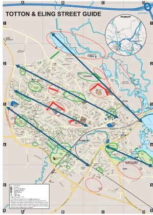
3.13 The Hampshire Local Nature Recovery Strategy was published in December 2025. It identifies priorities and mapped opportunities for nature recovery, including Areas of Particular Importance for Biodiversity, Areas that Could Become of Particular Importance for Biodiversity and potential measures for nature recovery. The TENP uses a combination of the Totton and Eling Green Corridors work ( see Figure 3) along with the LNRS , NFDC and NFNPA studies in defining and refining the Green and Blue Infrastructure Network. Particularly relevant measures include strengthening watercourse and floodplain habitats, wetland and woodland connectivity, hedgerows, urban green spaces, tree cover and biodiversity along walking, cycling and other transport corridors.
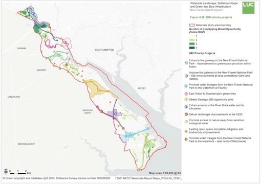
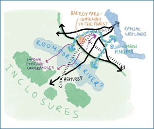
3.14 Clause B) i) of the policy recognises the opportunity to improve the existing ‘gateway’ between the New Forest National Park and Totton through the improvement of greenspaces and active travel connections. Opportunities include the delivery of flood risk mitigation and SINC improvements to facilitate water storage and mitigate surface flooding at Bartley Park. Eling Recreation Ground offers opportunities for accessibility improvements, habitat and biodiversity enhancements as well as pond and swale creation to complement the sport and recreation offer. The development and co-ordination of proposals within existing greenspaces, coupled with the West Totton Green Routes Scheme, will offer opportunities for active travel and linear habitat creation. This includes increasing public access along Bartley Water through the Town Centre and the provision of wider connections to the shore of Goatee Beach.
3.15 Clause B) ii) involves the delivery of a 2.7km multi-user route, accommodated on existing PRoW, providing wider linkages to King George’s Field (south of Strategic Site 1), Calmore playing field, Cheam Way Park, Testwood Recreation Ground and Testwood Lakes Nature Reserve. The opportunity exists to extend the route to form a loop which utilises some of the existing paths leading to Redbridge Road crossing and Lower Test Nature Reserve.
3.16 Clause B) iii) seeks to improve cycle infrastructure along Trotts Lane, with markings and improved crossings at Marchwood Road / Jacob’s Gutter Lane, the railway, and at the A326. Additional links through to the former quarry / new development off of Trotts Lane should be explored, as well as the creation of ‘gateway’ elements at entry paths into the NFNP and at the waterfront. As part of this overall improvement strategy, protection of ecologically sensitive sites along the routes will be important, including the provision of barriers and informational signage where necessary.
3.17 Clause B iv) identifies the Green Link corridor 1 Totton to Ashurst which aims to conserve and restore areas of coastal habitat, improve existing gateways between the New Forest National Park and the Waterside and enhance public open space provision and accessibility in and around Totton. It has identified several potential actions to support this:
- Animate existing underpasses with lighting, planting and/or public art.
- Manage vegetation along the A326 to further soften the influence of traffic at existing gateways.
- Provide subtle signage or other appropriate way-finding aid along the boundary of the National Park.
- Provide a new and improved walking and cycle route along Bartley Water connecting with Test Way in the east and Fletchwood Road in the west.
- Create a series of new multi-functional public open spaces along Bartley Water between Eling and Ashurst, incorporating Bartley Park.
- Create new wetland habitat along Jacob’s Gutter, for example at Pritchel’s Copse.
- Restore and conserve Eling and Bury Marshes in a ‘favourable’ condition